
Search Jefferson County Property Records
An address or owner name opens the door at the West Virginia Real Estate Assessment search. That lookup returns a parcel ID and legal description. Both are stronger keys for the County Clerk's deed index and the parcel map. The Clerk records ownership instruments, the Assessor links each parcel to an owner of record and assessed value, and the Sheriff/Treasurer tracks payments. Jefferson County property records are divided by function, so one screen rarely answers everything.
Match the record to the question. A deed proves a recorded transfer. A tax card shows the assessment. A GIS polygon places the parcel. None of these is a title opinion, appraisal, or boundary survey, so hold onto the parcel ID and deed reference as you move between offices.
- Search the state assessment portal by county and street name, owner name, or Full Parcel ID.
- Save the map number, parcel, sub-parcel, legal description, and any deed reference shown.
- Use the Clerk’s Document Inquiry System for the recorded deed, lien, release, or plat.
- Check the Sheriff/Treasurer tax record and the Jefferson County Parcel Viewer for tax and map context.
- Ask the custodian for an official copy or a record that is not available online.
Offices Behind Jefferson County Records
Each county office records a different chapter in a parcel's life. The Assessor's card is an assessment record. The Clerk's deed books preserve conveyances and related filings. The Sheriff-Treasurer's account shows tax charges and receipts, while GIS supplies the parcel geometry. A change in one system does not instantly prove the others changed. After a recent sale, read the recorded instrument first, compare the assessor owner field once it is processed, then ask the tax office about the bill for that parcel. Each office can confirm only its own file.
Three offices answer most property questions, but they do not hold the same records. The County Clerk is the recorder. The Assessor maintains valuation, ownership-of-record, and mapping data. The Sheriff/Treasurer takes tax payments and reports tax status. For zoning, permits, or site work, first check whether the parcel sits inside one of the five incorporated jurisdictions, since municipal rules apply there.
Jefferson County Recorder / Register of Deeds
393 North Lawrence Street
Charles Town, WV
304-728-3215
Jefferson County Assessor / Appraisal District
393 North Lawrence Street, Suite 100
Charles Town, WV
304-728-3224
Jefferson County Treasurer / Tax Collector
110 North George Street
Charles Town, WV
304-728-3220
Jefferson County Assessment Search Fields
The statewide West Virginia assessment search is the best first stop. Use it when you know an address, owner name, or parcel number. Select Jefferson County first. Use Street Name for an address-led search. Owner Name works for a person or entity. Full Parcel ID is best once you have the parcel key. District, Map Number, Parcel, and Sub-Parcel are separate inputs. Keep each part exactly as displayed rather than guessing a new format.
The form groups its controls into Hide, Basics, Appraisal, Sales, Advanced, and Prior Ownership views. The view controls which fields appear. Fields exist for county, district, full parcel ID, owner name, map number, property class, street name, tax class, sub-parcel, and land use. County, Property Class, Tax Class, and Land Use work as filters. Two display options can add the legal description and GIS parcel ID to results. These are alternate lenses on one county assessment record, not separate title records.
The landing page does not state exact partial-match rules or the coverage year. Try name and street variants freely. One failed query never proves no record exists.
| Search field | Useful when | Check the result for |
|---|---|---|
| Street Name | Only the site address is known | Multiple parcels on the road |
| Owner Name | A person or company is known | Spelling, trust, estate, or LLC variants |
| Full Parcel ID | A tax map or deed already names the parcel | Leading zeros and sub-parcel suffix |
| Prior Ownership | A past owner or transfer is the question | Confirm against the recorded deed index |
The statewide assessment search controls for Jefferson County appear in the image below. Those options narrow the assessment lookup. They do not replace the official deed record.
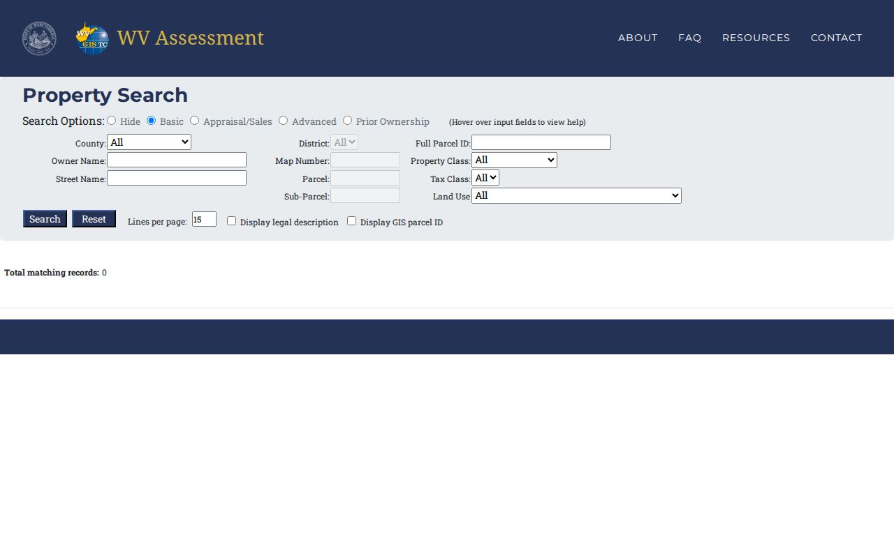
Enter the Full Parcel ID, District, or Street Name to reach an assessment record. Then carry that parcel key to the Clerk or the GIS layer.
Jefferson County Parcel Data Links
The Assessor's parcel viewer links a map view to owner and address searches. Its parcel service exposes fields such as WVgovPid, WVgovPAR, PARID, Map_Number, Parcel_Num, and PIN. It also offers TAX_YEAR, TaxReceipt, DeedLnk, and MapCardLnk. Those names show how one property gets labeled differently across assessment, mapping, and recording systems. They also give you several paths to the next record. One link may not open, but another will lead there.
GIS/Addressing maintains road, address, and general mapping data, while cadastral parcels belong to the Assessor. The address layer adds municipality, MSAG community, ESN, PSAP, unit, and status. It also records capture method and last-update fields. Such details can explain a bad or retired address point. They do not establish who owns the land. Save the parcel ID and deed reference before using a map as context.
The county publishes a complete GIS shapefile under a Data Usage Agreement. Downloading it requires a Digital Data Order Form. It does not post a current fee or refresh schedule. The free map and REST layer handle a parcel-by-parcel search. Bulk users should read the agreement and confirm the data date.
Jefferson County Deeds Before Indexing
Older Jefferson County property records live in a gap between easy and hard. Deed-book images from 1842 through 1919 are viewable online. Yet that run of books carries no name index. To search it, open Image Search. Pick a book and year from the County's book list. Then turn pages and read legal descriptions the slow way. A name alone will not pull up the older chain of title.
Some practical cautions apply. Historical record-room access is appointment-based. The County Clerk reports this while records move to the new building. Online images serve discovery well, but the official physical record stays with the Clerk. Do not assume 1919 marks the start of the only searchable era. The modern index cutoff is not pinned down. For older ownership, work backward from the current deed using its grantor and legal description. The Clerk can help with the right book once you know that much.
The County's notice about this unindexed deed-book image run matters. It changes how anyone searches older Jefferson County property records.
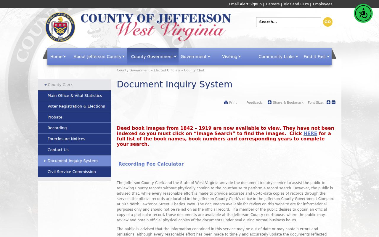
When a name search fails in this stretch of years, shift to the book and page images. Do not guess at an online-index date instead.
Record Sets for Jefferson County Property
Jefferson County property records work best as one linked set rather than separate files. A recorded deed supplies the transfer instrument and the legal description. Assessment and tax records bring values, exemptions, and payment status. GIS layers tie the parcel to streets and municipal lines. Court, probate, and permit files explain events that can shape a transfer. They can also shape a use of land.
| Record Type | What It Documents | Kept By | Access |
|---|---|---|---|
| Deeds and releases | Transfers, liens, easements, and recorded releases | County Clerk | Online inquiry; official copies at Clerk |
| Assessment roll | Owner of record, parcel, land and improvement values | Assessor | Free state search and parcel viewers |
| Tax bill | Current bill, payment, or delinquency status | Sheriff/Treasurer | Online tax search or office |
| Plats and parcel maps | Lots, parcel IDs, roads, and map context | Clerk, Assessor, GIS | Plat search, downloads, and GIS |
| Permits and zoning | Work history and allowed land use | City or county office | Municipal portal where available; direct request |
For recorded proof of a transfer, start with the Jefferson County deed records. Values, exemptions, and bills belong to the Jefferson County property tax records. A property-use question may also need a city permit file alongside the County parcel card.
When Jefferson County Meets City Limits
Municipal jurisdiction is a second map question. Charles Town, Ranson, Shepherdstown, Harpers Ferry, and Bolivar each run their own permits and zoning. County offices keep the deeds, assessment cards, and tax accounts. A postal address does not settle the boundary question. A town name or ZIP code does not settle it either. Check the city limit layer and ask the city planning office before assuming a town permit process applies.
Ownership records stay at the County even for parcels inside those five towns. Permits and zoning follow the incorporated boundary. County building-code rules reach unincorporated areas only. So check the municipality layer before requesting permit history. A postal city is not proof of town limits.
Charles Town's planning office holds zoning, grading, subdivision, and land-development files. Ranson publishes planning forms, maps, and an external permitting link. Shepherdstown requires permits for building or removal work. Much of that town also demands a Certificate of Appropriateness before a building permit. Harpers Ferry and Bolivar publish no searchable public portal. Their planning records need a direct municipal request.
Jefferson County Value and Tax Records
The Assessor sets fair market value on real and personal property and keeps the assessment record. West Virginia generally assesses at 60 percent of current fair market value under W. Va. Code §11-1C-1(d), with exceptions for farm and managed timberland. State law also calls for three-year cycles in which each parcel is visited to catch value-changing improvements. The office does not publish a particular card's full value history or the County's last revaluation year online.
The assessment is not the bill. The Assessor's roll supports value and exemption review. The Sheriff/Treasurer tracks the amount due, payments, and delinquency. The state search offers Appraisal/Sales and Prior Ownership views. The County's tax page links to an online tax search and payment system. Confirm any current balance with the tax office, since coverage details are not spelled out there.
Jefferson County Plats and Map Layers
The Assessor publishes Plat Books 1 through 25 as individual TIF or JPG files. Finished tax maps and historic maps sit alongside them. GIS/Addressing lists a subdivision-development-pattern map. It also posts January 2026 road maps and the 2025 zoning map recorded March 26, 2026 in Plat Book 27, Page 651. Together these sources tie a modern parcel number to its context. That context includes its lot, block, road, and zoning.
A recorded plat can show lot lines, dedications, easements, and adjoining lots. The deed's legal description names the controlling land record. GIS polygons are reference data, never a survey. A metes-and-bounds parcel may require matching deed calls against older roads, streams, and adjoining tracts. So do not trust a simple lot number alone.
Probate Transfers in Jefferson County
Estate files often explain why an owner of record changes without any sale taking place. Jefferson County Probate holds wills, qualification papers, inventories, notices, and real-property transfer records. Real estate held solely by the deceased may need probate. Jointly held property with survivorship can pass outside the estate. So can an asset with a named beneficiary. Either way, the deed is the land record tying the estate event to the parcel. A fiduciary instrument can serve that role too.
Call a probate clerk first. County staff walk you through process steps, though they cannot give legal advice. A deed may name an executor or administrator. Treat that role as your clue. Request the probate file from the Clerk. Death and marriage certificates can help confirm a name link. But current vital records stay restricted.
Jefferson County Copies and Access
West Virginia's Freedom of Information Act opens a route when a record is not in any portal. A public body must respond within five days. Weekends and legal holidays do not count. The custodian can charge actual reproduction costs. Staff search time is not billable. Name the record clearly, state your preferred format, and send the request to the office that actually holds it. The Clerk, Assessor, Treasurer, and GIS office keep separate queues.
For copies, the County Clerk charges $1.50 for the first two pages. Each additional page in a document is $1. The Recording Department accepts documents from 9 a.m. to 4 p.m. Anything after 4 p.m. is recorded the next business day. E-recording runs through Simplifile, CSC/eRecording, and eRecording Partners Network. The Clerk's page links its fee schedule, fee calculator, sales-listing form, and plat search.
The statute sits at W. Va. Code chapter 29B. A permit, map, or archive file may not be online. A written records request to the custodian is the practical path then.
Limits of Jefferson County Property Records
Jefferson County property records carry real weight. They support ownership research, purchase diligence, tax review, and local history. They do not guarantee clear title. The County Clerk cautions that Document Inquiry information may be out of date or contain errors and omissions. So get official copies under seal from the Clerk. Remember, too, that a map line is not a surveyed boundary. An assessed value is not a sale appraisal.
Use records lawfully. Jefferson County property records are for legitimate property, estate, tax, and civic research. Do not use an owner name or address to stalk, threaten, or harass anyone. Seek a title company for title work and a licensed surveyor for a boundary question.