
Search Jefferson County Properties
The statewide West Virginia assessment search covers Jefferson County by address, owner, and parcel. Begin with whatever fact you trust most. For an address, pick Jefferson County and enter the street name. Add any parcel component you know. For an owner, try name variants that matter. A deed or tax receipt already in hand supplies a parcel identifier. The Full Parcel ID route then cuts through same-name clutter.
Treat the search as a locator rather than a full property file. Carry the parcel number and legal description into the County Clerk's Document Inquiry System. That yields the recorded instrument. The Assessor or map viewer adds value and parcel context. Ask the Sheriff/Treasurer about any current balance. The county's landing page does not spell out the portal's partial-match rules. It also skips its full coverage years.
- Choose Jefferson County, then enter a street name, owner name, or full parcel ID.
- Open the likely match and note its district, map number, parcel, sub-parcel, and legal description.
- Compare the situs address with the mailing address and check for a recent transfer.
- Use the Clerk’s deed index and GIS map to confirm the same parcel from separate records.
- Request an official copy from the Clerk if a document will support a legal or financial decision.
Jefferson County Assessment Search Fields
With a parcel number in hand, the full parcel ID or map number is steadier than a street label. Different systems may abbreviate a street label differently. The assessment form also splits out several fields. These include owner name, street name, district, tax class, property class, sub-parcel, and land use. Its views are Basics, Appraisal, Sales, Advanced, and Prior Ownership. They reveal different parts of the same card. Switching views does not create a second parcel. Legal description and GIS ID can be turned on as display fields.
The assessment search is more than a single address box. Those views open separate paths into the tax roll. County-specific choices load once Jefferson County is selected. Hover tips offer search help. But the public landing page says nothing about exact-match behavior, result caps, or historical coverage. So verify a result instead of trusting one failed term.
| Field | How it helps | Known format note |
|---|---|---|
| County / District | Sets the geographic roll | Select Jefferson County; district is optional |
| Street Name | Finds parcels along an address road | Exact and partial rules are unstated |
| Owner Name | Finds parcels indexed to a person or entity | Name format rules are unstated |
| Full Parcel ID | Targets one parcel once known | Separate Map, Parcel, and Sub-Parcel fields also exist |
| Property Class / Tax Class / Land Use | Narrows a broader set | Options load after county selection |
| Display legal description / GIS parcel ID | Adds cross-reference data to results | Optional checkboxes |
The assessment search controls shown here are the fields documented for Jefferson County, and the screen itself does not guarantee any particular parcel result.
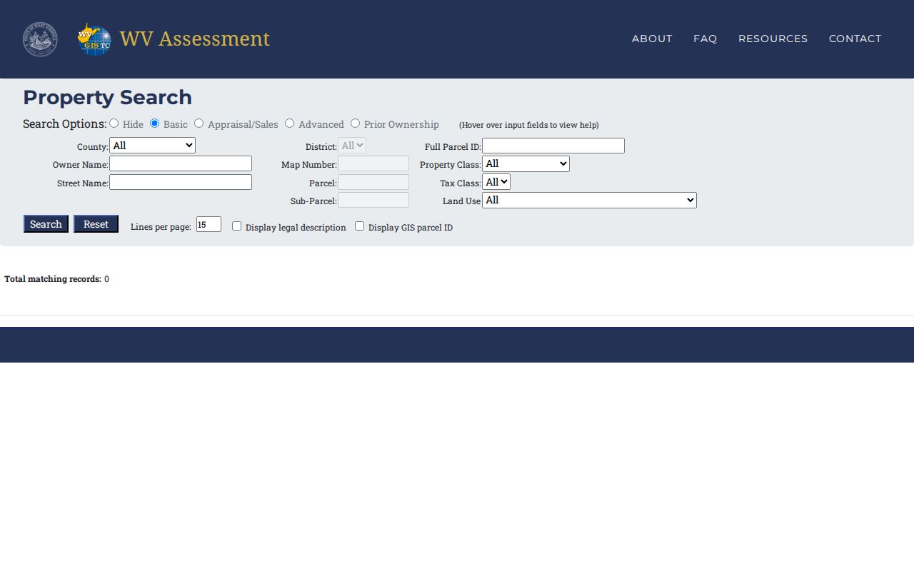
Use its Full Parcel ID, District, and Street Name fields to reach the assessment record, then carry the parcel key to the Clerk or a GIS layer.
Jefferson County Parcel IDs and GIS
The parcel GIS service publishes identifiers such as WVgovPid, WVgovGen, WVgovPAR, PARID, COUNTY, Map_Number, Parcel_Num, TAX_YEAR, and PIN. It also carries property type, neighborhood, tax receipt, deed, and map-card link fields. A map number can point toward a plat or tax map. A deed link is a lead to a separate recording record. Preserve the full value exactly as displayed. A leading zero or sub-parcel digit can separate neighboring lots with similar street addresses.
Jefferson County records carry several parcel-key labels. These include Full Parcel ID, Map Number, Parcel, Sub-Parcel, WVgovPid, WVgovPAR, PARID, Map_Number, Parcel_Num, and PIN. Those labels are not a license to retype an identifier from memory. Keep the punctuation and leading zeros intact, and note which system gave you each key. The parcel REST layer also holds TAX_YEAR, Property_T, Neighborho, TaxReceipt, DeedLnk, and MapCardLnk.
A street name can return a whole block of parcels. A parcel number narrows the field to one tract. The GIS map then shows where its polygon meets roads and neighboring parcels. Jefferson County GIS/Addressing maintains addressing and general layers. Parcel cadastral data belongs to the Assessor. When map and assessment labels differ, carry both into the deed search. Do not assume two separate properties.
What Jefferson County Search Results Show
Keep the parcel ID, district, tax year, legal description, and the exact address string that produced the card. If an address lookup stalls, retry with the map number and parcel components. You can also try the GIS viewer's Find options for Parcel_ID, Owner, or Address. Change one search key at a time. That way you know whether a different result came from a street spelling, an owner-name variant, or another lot. The portal's documented controls locate a card well. But they carry no guarantee that every current record appears online.
The assessment search can link an owner name or street to a parcel. Yet a populated card is the real goal. Use the list below as a verification checklist rather than a promise of identical fields on every result. The statewide portal does expose optional legal-description and GIS-ID displays. The parcel service schema exposes tax and document links.
| Owner and addresses | Compare owner name, situs address, and separate mailing address where shown. |
|---|---|
| Parcel keys | Record district, map, parcel, sub-parcel, and GIS ID as displayed. |
| Legal description | Check whether the optional display is available; compare it with the deed. |
| Assessment | Review land, improvement, and total values in the applicable view. |
| Transfer detail | Verify sale date, consideration, and deed reference with the recorded instrument. |
| Tax and map links | Use TaxReceipt, DeedLnk, and MapCardLnk in the parcel schema when available. |
Cross-checks matter because no result guarantees its own refresh schedule. A search result is not a title opinion, and the map polygon is not a boundary survey. For deed detail, the Jefferson County deed records explain the Clerk's index and the route to an official copy.
Compare Jefferson County Search Keys
Every search key answers a different question. Street Name is the pick when all you have is an address. Owner Name helps when you are tracing land held by a person or a company. That route can miss trusts, life estates, estates, LLCs, and spelling changes. Full Parcel ID is the tightest search. It works once some other property record hands you the number.
| Search Key | Best For | Where It Works | Watch Out |
|---|---|---|---|
| Street name | Start with a location or find several parcels on one road | Assessment search and GIS | Do not assume partial-match behavior |
| Owner name | Locate parcels tied to a person or entity | Assessment search; Clerk index for deeds | Try documented name variants |
| Parcel ID | Match one parcel across systems | Assessment, GIS, tax, and deed references | Preserve map, parcel, and sub-parcel parts |
Not a title search. A Jefferson County property search is a way to find records, not a guarantee that title is clear. A title company or attorney must review the chain and other legal interests.
Jefferson County Address Point Fields
Jefferson County keeps its address-point layer as its own GIS source. Each record can carry a full address, road name, municipality, unit number, and emergency-service fields. Expect an ESN, a PSAP, and an MSAG community. Also expect an address class, a point type, a capture method, a status, and a last-update date. None of that describes ownership. An address point marks an assigned site address, full stop. It is not a surveyed corner. It is not a deed description. It does not promise the Assessor spells the street the same way.
The layer earns its keep when a street number looks wrong. It also helps when a postal label will not say which town covers a parcel. When the street search returns several candidates, compare the municipality and road against the parcel outline. Check the recorded plat too. Then open the tax card. The address inventory describes an address record and its emergency-service geography. So treat it as one clue among several in a Jefferson County property search.
| Address match | Full Address, Full Road Name, number prefix/suffix, unit type and unit number |
|---|---|
| Jurisdiction | Municipality Name, Place Name, and MSAG Community |
| Service area | ESN and PSAP fields |
| Record status | Address class, point type, capture method, status, and last update |
Jefferson County ties a 2001–2008 readdressing project to its current road and subdivision indexes. If a parcel lookup stalls on an old street number or name, that readdressing context may explain why.
Jefferson County Appraisal Views
The portal's Appraisal/Sales and Prior Ownership views reach beyond the basic current roll. Use Appraisal/Sales to compare assessment figures with recorded-sale context. Use Prior Ownership when an earlier name matters. The portal publishes no guaranteed live parcel card. It offers no precise last-sale field. And it states no roll-refresh interval. So do not treat those views as a title abstract. Do not assume every historical owner appears.
An owner name on an assessment record is a clue, nothing more. For a recent transfer, the newest recorded deed is the stronger source. A mailing address can differ from the situs address. The roll can also lag a closing. Write down the deed date and the recording date separately. If the gap matters, ask the Assessor whether its roll has been refreshed.
Jefferson County Search Fallbacks
Write down the exact parcel ID, map number, owner spelling, and street address you tried. Hand those values to the office that holds the record. Do not ask one clerk to search every county database. The County Clerk can check its document inquiry records and advise on an official copy. The Assessor can explain a property card. The tax office can confirm a receipt or balance.
Some records sit outside online access. For those, a West Virginia Freedom of Information Act request goes to the custodian. Chapter 29B sets a maximum five-day response window, weekends and legal holidays excluded. It allows actual copy cost rather than a staff search fee. A specific request can cover public material that is not posted online.
Remember that the County Clerk's Document Inquiry System is informational only. It may omit or misstate details. Official copies under seal come from the Clerk. Historical room access is by appointment while records move to the new building. Call 304-728-3215 or email the Clerk before planning a visit.
For an assessment value, contact the Assessor at 304-728-3224. For a current tax balance, use the tax office page. You can also call the Sheriff/Treasurer at 304-728-3220. Each office answers for its own piece of the property record.
Terms in a Jefferson County Search
Several labels in a Jefferson County property record look alike but mean different things. Keep them straight when you cross from assessment records to deeds or plat maps.
- Parcel ID
- A tax-map key for a tract. Jefferson County systems expose it as Full Parcel ID or as Map Number, Parcel, and Sub-Parcel.
- Situs address
- The address where the land is located.
- Mailing address
- The address used for assessment or tax mail; it may be elsewhere.
- Owner of record
- The name tied to the current assessment roll, which may lag a new deed.
- Legal description
- The written land description in a deed or plat, such as lot and block or metes and bounds.